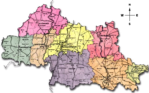
South Dinajpur
 Dakshin Dinajpur or South Dinajpur (Bengali: দক্ষিণ দিনাজপুর জেলা) is a district
of the Indian state of West Bengal. Created on 1 April 1992 by the division of the
erstwhile West Dinajpur district, it comprises two subdivisions: Balurghat and Buniadpur.
As of 2011 it is the least populous district of West Bengal (out of 19).
Census Data
| Description |
2011 |
2001 |
| Actual Population |
1,670,931 |
1,503,178 |
| Male |
855,104 |
770,335 |
| Female |
815,827 |
732,843 |
| Population Growth |
11.16% |
22.15% |
| Area Sq. Km |
2,219 |
2,219 |
| Density/km2 |
753 |
677 |
| Proportion to West Bengal Population |
1.83% |
1.87% |
| Sex Ratio (Per 1000) |
954 |
951 |
| Child Sex Ratio (0-6 Age) |
948 |
966 |
| Average Literacy |
73.86 |
63.59 |
| Male Literacy |
79.63 |
72.43 |
| Female Literacy |
67.81 |
54.28 |
| Total Child Population (0-6 Age) |
178,374 |
246,034 |
| Male Population (0-6 Age) |
91,564 |
125,157 |
| Female Population (0-6 Age) |
86,810 |
120,877 |
| Literates |
1,102,355 |
799,479 |
| Male Literates |
607,992 |
467,296 |
| Female Literates |
494,363 |
332,183 |
| Child Proportion (0-6 Age) |
10.68% |
16.37% |
| Boys Proportion (0-6 Age) |
10.71% |
16.25% |
| Girls Proportion (0-6 Age) |
10.64% |
16.49% |
Divisions
Administrative subdivisions
The district comprises two subdivisions: Balurghat and Buniadpur. Balurghat consists
of Balurghat municipality and four community development blocks: Hili, Balurghat,
Kumarganj and Tapan. Buniadpur subdivision consists of Gangarampur municipality
and four community development blocks: Gangarampur, Banshihari, Harirampur and Kushmandi.
Balurghat is the district headquarters. There are 8 police stations, 8 development
blocks, 2 municipalities, 65 gram panchayats and 2317 villages in this district.
Other than municipality area, each subdivision contains community development blocs
which in turn are divided into rural areas and census towns. In total there are
2 urban units, both of which are municipalities. Chak Bhrigu and Baidynathpara were
two urban outgrowths noted in census 2001.
Balurghat subdivision
- Balurghat: municipality
- Hili (Community development block) consists of rural areas only with 5 gram panchayats.
- Balurghat (Community development block) consists of rural areas only with 11 gram panchayats.
- Kumarganj (Community development block) consists of rural areas only with 8 gram panchayats.
- Tapan (Community development block) consists of rural areas only with 11 gram panchayats.
Buniadpur subdivision
- Gangarampur: municipality
- Gangarampur (Community development block) consists of rural areas only with 11 gram panchayats.
- Bansihari (Community development block) consists of rural areas only with 5 gram panchayats.
- Harirampur (Community development block) consists of rural areas only with 6 gram panchayats
- Kushmandi (Community development block) consists of rural areas only with 8 gram panchayats.